



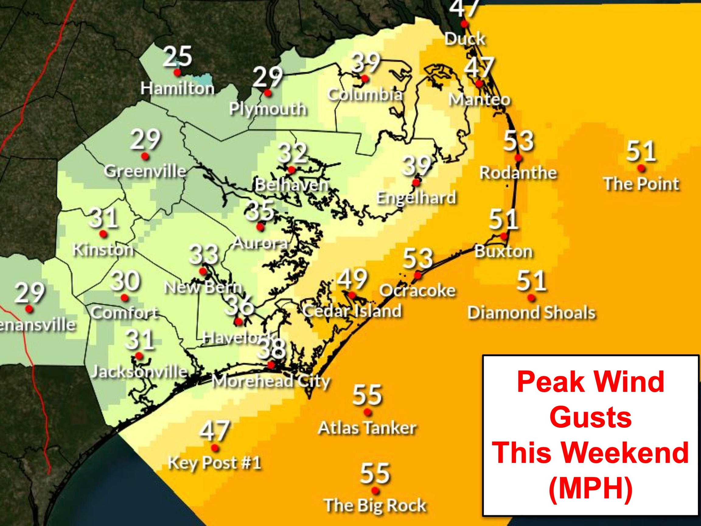
Dare County Emergency Management is closely monitoring a developing coastal storm that is expected to bring hazardous conditions to the Outer Banks beginning Saturday, October 17, 2026, and continuing into early next week.
The National Weather Service at Newport/Morehead City, N.C., has issued a hazardous weather briefing for all areas of Dare County. A prolonged period of moderately strong north to northeast winds is forecast, creating the potential for beach erosion, coastal flooding, ocean overwash and dangerous surf conditions. These impacts could affect travel, particularly along N.C. Highway 12 on Hatteras Island. While impacts are expected to occur, confidence in the storm’s strength and duration is currently low, making the exact timing and severity of those impacts difficult to forecast at this time. For the latest briefing from the National Weather Service, visit weather.gov/mhx.
The North Carolina Department of Transportation (NCDOT) is preparing for potential travel disruptions, with road and ferry crews monitoring conditions and preparing for possible impacts. Motorists should anticipate changing travel conditions and potential delays or road closures as the storm develops.
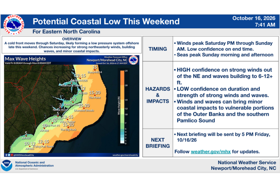
Expected impacts include:
- Large waves (6-12 feet) bringing very dangerous surf conditions, life-threatening rip currents and beach erosion
- Moderate to strong N to NE winds with gusts of 40 mph to 50 mph
- Minor to moderate ocean overwash at vulnerable locations along the Outer Banks, particularly portions of N.C. Highway 12 on Hatteras Island
- Minor soundside coastal flooding along the southern Pamlico Sound (Hatteras Island)
Ocean overwash is possible into next week. Businesses should try to arrange deliveries now to have stock on hand should deliveries be curtailed by road closures.
Additional watches and warnings may be issued by the National Weather Service as the storm develops and conditions evolve. Residents and visitors are encouraged to monitor weather forecasts and stay informed about changing conditions. To receive emergency text alerts from Dare County, text DareEmergencyAlerts to 77295.
Prepare to Protect Property from Coastal Flooding & Overwash:
Residents and visitors who are located along the oceanfront—particularly in areas with compromised dune structures—will see the greatest potential for impacts. If you are located in an area with vulnerable dune structures, be ready to take action to protect property from ocean overwash. On Hatteras Island, vulnerable areas include the north end of Rodanthe.
If you are standing at ground level and there is little to no dune between you and the ocean, you are in a vulnerable area.
Road Conditions & Travel:
Travel—particularly along vulnerable sections of N.C. Highway 12 on Hatteras Island—has the potential to become dangerous due to forecast strong winds, rainfall and ocean overwash, which could result in road closures. Residents and visitors are encouraged to keep a close eye on the forecast and to monitor DriveNC.gov for the latest road conditions. Ferry operations may also be affected by deteriorating weather conditions. Visit NCFerry.org for more information.
Visitors planning to travel to or from Hatteras Island should prepare for the possibility of extended travel disruptions. Those with upcoming travel plans should consider whether they can adjust their schedules and should make arrangements for essential needs in the event that they are unable to leave Hatteras Island temporarily. This includes ensuring that you have an adequate supply of necessary prescription medications and considering any upcoming medical appointments or other time-sensitive appointments.
Businesses should try to arrange deliveries now to have stock on hand should deliveries be curtailed by road closures.
Residents and visitors should be prepared to limit travel as conditions deteriorate. If travel is necessary, use extreme caution and remain alert for changing road conditions. Never drive through flooded roadways, and never drive around or past a barricade or other barrier closing a road. Even a few inches of moving water can sweep a vehicle off the roadway.
For the latest road conditions, visit DriveNC.gov and follow the North Carolina Department of Transportation and NCDOT N.C. 12 on Facebook. Travelers should also monitor NCDOT Ferry Division updates for potential changes to ferry service.
Dare County Emergency Management will continue to monitor the storm and share updates as additional information becomes available. For ongoing information and local preparedness resources, visit DareNC.gov/Storm.
Information regarding Dare County departmental closures and cancellations of programs and services will be posted at DareNC.gov/Storm should services become impacted.

